

CARTO add CDRC dataset to their Spatial Data Catalog and use it to explore UK retail centres
CARTO, one of the world’s leading location intelligence platforms has added CDRC’s Retail Centre Boundaries dataset to its Spatial Data Catalog. The dataset contains spatial boundaries for Retail Centres across the UK, as well as measures of supply vulnerability, online exposure, a clone town measure, E-resilience, and a hierarchical classification. It is based on a hexagonal H3 grid, designed for spatial analysis at scale. This gives the dataset some unique benefits when cross-analysing with other datasets.
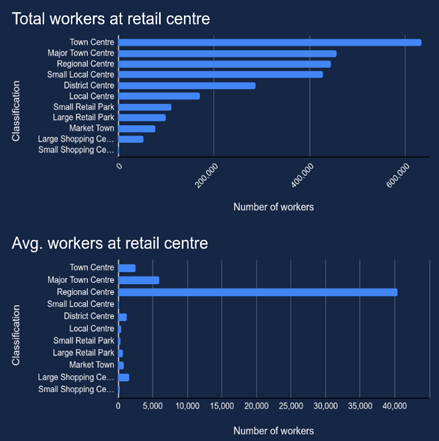
Miguel Álvarez, Lead Data Scientist and Helen McKenzie, Geospatial Advocate at CARTO took advantage of this to explore UK retail centres. They looked for patterns by cross-analysing CDRC data with external datasets from CARTO’s extensive Spatial Data Catalog. One insight from their analysis is that, on average, Regional Centres have by far the highest number of employees per centre, averaging at around 40,000 people working within them. However, in total Town Centres (e.g. Arnold, Nottingham) are by far the biggest employer with over 600, 000 people working there.
See what else the researchers discovered at CARTO data science.
Another CDRC dataset available on CARTO’s Spatial Data Catalog is our “Retail Centres Typology”, which is a previous version of Retail Centre Boundaries, based on 2015-18 data. However, the two datasets are not directly comparable, as they contain different information and geometric types.
If you want to go exploring using a CDRC data please visit our data catalogue, which has over 80 datasets covering the following topics: Population & Mobility; Retail Futures; Transport & Movement; Finance & Economy; and Digital.
[Adapted from original article].