Home » Archives for rtrumble

Digital Poverty Research

Map showing digital poverty index in South Yorkshire

Understanding Digital Poverty in South Yorkshire

Researchers at the University of Sheffield used several CDRC datasets as part of their research into digital poverty in South Yorkshire. The South Yorkshire Mayoral Combined Authority (SYMCA) wanted a better understanding of how digital poverty and digital exclusion play a role in the region, and how to build digital capability in the region, particularly for social groups identified as at risk.  

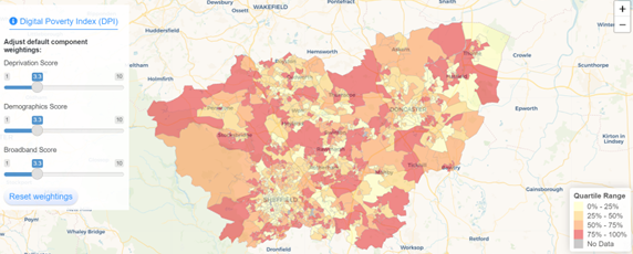
The research team mapped digital poverty in the South Yorkshire region. This allowed them to assess the areas at greater risk of digital poverty, by highlighting the intersections of different inequalities and barriers that different social groups in the region experience. This provided a place-based nuanced understanding of which populations and areas are more affected and thus potentially excluded from the labour market, education, and services due to being digitally excluded.

Screen shot of the visualisation tool

The findings are helping SYMCA create a positive impact in the region: they will inform the region’s COVID-19 recovery plan and the agenda for implementing their Inclusion Plan and is providing feasible and research- and evidence-informed pathways towards alleviating digital exclusion and digital poverty. Besides supporting the most disadvantaged citizens, by leveraging the findings of this project, SYMCA will be better able and prepared to create further digital development opportunities in the region, e.g., by supporting the development of literacies, entrepreneurship, and talent- thus supporting its economic recovery.

For more information see the project webpage: https://www.sheffield.ac.uk/office-for-data-analytics/digital-poverty

The visualisation tool is available here: https://sheffield-university.shinyapps.io/Digital-Poverty/

The project was funded through the Knowledge Exchange Support Fund (QR Policy and Covid Recovery) and supported by the South Yorkshire Office for Data Analytics Pilot.


Masters Dissertation Scheme: applications open

Thinking of applying to our 2023 Masters Dissertation Scheme (MDS)?

We asked the winners of the 2022 MDS prize about what attracted them to the MDS and how they got involved. In these short videos Aindrila and Alex tell you about the benefits of the MDS and how their experience, working with industry, is supporting their career development.

Disa Ramadhina, winner of the Best Dissertation 2021, went straight to a Data Analyst role, following her Masters. In this YouTube clip Disa describes how she was able to add value to the partnership between academia and industry and how the MDS experience helped progress her career at Entain.

2023 Masters Dissertation Scheme Launch

Group of three data scientists chatting informally - one is using a laptop and one has back to camera

Thinking of applying to our 2023 Masters Dissertation Scheme (MDS)?

Ten years ago, the Economic and Social Research Council funded a nationwide collaborative Masters Dissertation Scheme for the first time. Over the years, businesses, government and third sector organisations have collaborated with universities throughout the UK to allow Masters students to develop practical solutions to problems through applied research, often using their own sources of data that are not usually available for student projects. Sponsoring organisations solve problems, students get real world problem-solving experience, and many students have gone on to work for the organisations that sponsored their research projects. This year’s projects can be viewed here. As in previous years, there is likely to be very considerable interest in these projects, so interested students are advised to apply as soon as possible!

Group of three data scientists chatting informally - one is using a laptop and one has back to camera

Quantifying state-led gentrification in London

CDRC data used to understand population displacement from gentrified London council estates with surprising results

New research using our novel Linked Consumer Registers has found that the demolition and associated redevelopment of council estates in London has displaced former residents, potentially separating them from their existing employment, education and care networks. Yet around 85% of the displaced in remain London, and most stay within the same Borough. This suggests that the scale of displacement may be less than has previously been suggested, particularly in the popular press. However, there is also evidence of increasing numbers of moves out of London to the Southeast and East of England.

The full paper in published in Environment and Planning A, authored by Jon Reades, Loretta Lees, and Phil Hubbard.

Latest version of Access to Health Assets and Hazards (AHAH) released

Latest version of Access to Health Assets and Hazards (AHAH) released

The Consumer Data Research Centre and Geographic Data Science Lab are proud to announce the latest release of their data resource, “Access to Healthy Assets and Hazards” (AHAH).

AHAH is a multi-dimensional index for Great Britain measuring how “healthy” neighbourhoods are based on the locations of services that are ‘assets’ or ‘hazards’ for health in each area.

AHAH is calculated based on data from 15 indicators divided into four domains:

  • Retail environment – fast food outlets, pubs, off-licences, tobacconists, gambling outlets
  • Health services – GPs, hospitals, pharmacies, dentists, leisure services
  • Air quality – air pollution levels for Nitrogen Dioxide, Sulphur Dioxide and Particulate Matter (PM10)
  • Natural environment – green spaces and blue spaces

The resource allows researchers and policy makers to understand which areas have poor environments for health and helps to move away from treating features of the environment in isolation to provide a comprehensive measure of neighbourhood quality.

AHAH is produced for Lower Super Output Areas for England and Wales, and Data Zones for Scotland. Component inputs for this index use data that is the most up-to-date as of March 2022.

All of the individual indicators to AHAH have also been made freely available in the data resource in a push for opening up small area health data. As such, it provides one of the most comprehensive free data resource available for such data. You can freely explore how your local area compares on our data at https://mapmaker.cdrc.ac.uk/#/access-healthy-assets-hazards. AHAH and all of the individual indicators are openly available at https://data.cdrc.ac.uk/dataset/access-healthy-assets-hazards-ahah.

Changes from previous versions

The latest version of AHAH includes several methodological and conceptual refinements following extensive public feedback on previous versions.

Most noticeable is the change in how we measure accessibility to green spaces. We received a lot of user feedback, especially from rural communities, who did not feel that measuring distance to nearest accessible park or green space was the best measure since it under-represented rural areas (i.e., farmland that is green but not necessarily accessible).

In response, we have updated the measure to use a satellite derived measure of the total green space (NDVI). We note here the measure is for the resident population and their surrounding contexts.

This has improved the accuracy for measuring access to overall green space. These changes have resulted in changes in the overall AHAH index value, mostly seeing rural areas with good access to green spaces having better overall scores. As a result, we would suggest caution in making comparisons over time between the overall AHAH index.

We have also further updated our statistical approaches to give more accurate accessibility estimates and utilize GPU support for faster processing.

All code for reproducing AHAH can be found here.

Future High Streets

CDRC data used to re-imagine high streets

Researchers from CDRC have provided vital data analysis as part of London Borough of Camden’s Future High Streets programme

The aim of the programme is to ‘re-imagine’ high streets for the 21st century and ensure they are the heart of community and economy.

Even before the COVID-19 pandemic, high streets across Britain were facing a multitude of challenges, including: 

  • the ongoing shift away from traditional retail to online shopping
  • a decline in footfall
  • higher costs due to rising business rates and commercial rent

The pandemic compounded these issues. National lockdowns closed non-essential stores and changed behaviours in various ways, with fewer commuters visiting central London locations.

In response, Camden Council devised the Camden Future High Streets programme to support its high streets through the pandemic and into a robust recovery and ready to face the future.

Professor James Cheshire, Deputy Director of the Consumer Data Research Centre and his team, collaborating with Camden, performed an extensive search for high street related data and datasets in six main categories: high street boundaries, mobility, economic, retail, social and demographic, and sustainability. They used pre-existing data to show changes over time and differences between high streets in order to inform local policy.

“We’re sort of a data of broker,” explains James. “Part of that role is acquiring data, processing it, and giving it back in a way that people can make good use of. But I also think we can be an impartial advisor on what data is good and what data is less good. We don’t have any real sort of commercial imperative to be selling a particular data product so we can impart an honest view.”

James and his team produced a detailed report, Data for Future High Streets, containing their insights and six recommendations of how data can be better used to improve resilience and vibrancy of high streets.

Abigail Hill, played an important role in the project, with elements of her PhD research included the report and utilised by Camden.

“The knowledge exchange with the London Borough of Camden has enriched my research that focuses on measuring the resilience of British high streets,” she says. “The project provided invaluable insights into high street regeneration projects and decision making, enabling my research to make an impact on local policy.”

Councillor Danny Beales, Cabinet Member for Investing in Communities, Culture, and an Inclusive Economy (Camden Council), comments: “It’s been a productive collaboration. Working with UCL provided valuable insights into how London Borough of Camden can use data, including the data we already hold, more effectively to support the recovery of our high streets after COVID.”

You can read more about the Resilience of British High Streets to the COVID-19 Lockdown Restrictions here.