CDRC research team shortlisted for ESRC Celebrating Impact Prize
A team of researchers from the Consumer Data Research Centre have been announced as finalists in this year’s ESRC Celebrating Impact Prize, in recognition of the work they are doing to improve access to healthy and sustainable diets for customers of major food retailers.
The annual prize, now in its 11th year, recognises researchers who achieve outstanding economic or societal impact from their research.
The Nutrition and Lifestyle Analytics Team, which is led by Professor Michelle Morris and includes Dr Emily Ennis, Dr Francesca Pontin, Dr Victoria Jenneson and Dr Stephen Clark, are one of two finalists in the Outstanding Business and Enterprise Impact category.
Professor Michelle Morris, Professor of Data Science for Food at the University of Leeds commented:
“I am very proud to lead such a brilliant team and for us to be included amongst such inspiring finalists for these Celebrating Impact Prizes.
Food is at the heart of some of the world’s greatest challenges and as a team we are driven to deliver impactful research that makes healthy and more sustainable diets available to all.
We couldn’t do this work without industry partners passionate about driving change, the support of the ESRC and University more widely – thanks to you all.”
Dr Emily Ennis, CDRC’s Research and Impact Manager welcomed news of the team’s recognition:
“CDRC was developed to use consumer data to provide unique insight into a diverse range of societal and economic challenges. This research is exactly this.
It’s exciting to see the team using these real-world data to deliver real-world impact: changing how businesses are run and the products they provide, in order to ensure UK consumers have access to affordable, healthy, and sustainable food.
Michelle and the team continue to grow their network and research power, and we’re so excited to be a part of where it goes next.”
The winners will be announced at an awards ceremony on 15 November 2023, as part of the ESRC Festival of Social Science.
Case Study: Leeds Best City Planning: Harnessing 2021 Census
The census provides an extensive snapshot of society, and it is utilised by the government and local authorities to inform policy and resource allocation. However, it is difficult to utilise this resource without prior experience in data manipulation and analysis.
Project overview This project aimed to provide access to Leeds census data for a range of end-users in the form of a data dashboard. The Intelligence & Policy Team at Leeds City Council (LCC) receives a substantial number of census-related data requests from councillors, different departments, and members of the public. The process of downloading, manipulating, and analysing census data can be time-consuming and tedious. This dashboard aimed to minimise the time spent on this process, providing insights at the click of a button.
Data and methods Census data that is open-access and meets statistical disclosure control (SDC) limits, can be used in different combinations. For this project, census data were downloaded from the Office for National Statistics (ONS) or Nomis (National Online Manpower Information System) websites. Data were downloaded for both the 2011 and 2021 Censuses, and at the Ward and Lower Layer Super Output Area (LSOA) scales. The spatial boundary data (ESRI Shapefiles) were provided by LCC but can also be accessed online. This was converted into TopoJSON files, and their coordinate reference systems (CRS) changed in a free online resource, ‘Mapshaper’. These spatial transformations were necessary because the software chosen to host the dashboard, Microsoft PowerBI, requires files to be in this format and with a specific CRS (EPSG: 4326).
Data wrangling took place in the Power Query Editor (PQE) in PowerBI. The census data were downloaded in CSV format and read into PowerBI. In the PQE, steps such as removing unnecessary columns, editing column headers, and merging data, could take place, allowing the appropriate format required for the PowerBI dashboard. In the Data Model, connections were formed between variables (columns) that allowed the visuals to interact with each other in the dashboard.
The theme/style of the dashboard were kept consistent across the pages. The colour scheme, map shape, slider and some buttons appear in the same position on every page. The visuals ranged between Clustered and Stacked Bar Charts, Shape Maps, Doughnut Charts and Tornado Charts (Downloaded Visual). Some of the visuals interact with each other on the page, and by selecting an area or multiple areas on the map (Ward or LSOA) the local statistics are displayed on the page. Some visuals (which are specified) can be clicked to return a choropleth map. DAX equations have been implemented on some graphics, demonstrating the percentage (%) change between 2011 and 2021 across categories of a variable and spatial scale. Other graphics have tooltips (pop ups) which provide further information such as totals and proportions (%).
In the dashboard users can also click between 2011 and 2021, Ward and LSOA data. There are links to download the data and access the Leeds Observatory on all pages. Tutorial, contents, information, and quick links pages are also available in the dashboard allowing users to access further information and help if they require.
The dashboard will initially be published on the Leeds Observatory and Consumer Data Research Centre (CDRC) websites, allowing for public access. The dashboard will also be published by Leeds City Council at a later date.
Key findings This census data dashboard tool will allow a range of end users to access census data at the click of a button, which will save significant resources.
Accessibility was a significant consideration in the design of the dashboard, and we believe we have achieved this. Clear guides on how to navigate through the dashboard and help pages will aid users’ ability to use the tool (See Figure 1 for an example).
This project has demonstrated that using Microsoft PowerBI software is an effective way to produce a general-purpose dashboard for Leeds census data. Through user-testing it has been found that the dashboard is easy to use and understand for a range of end-users. Leeds City Council have begun to use this tool and it has proved effective for what they wanted to achieve. There are many potential uses of the dashboard, so it is promising that initial findings suggest it is working successfully.
We have been successful in implementing all the topics that were set out at the start of the project, at two different spatial scales, and over two iterations of the census (See Figure 2 for an example). We also have gone beyond the initial scope of the project, by implementing DAX measures (allowing comparisons between the 2011 and 2021 censuses). However, implementing complex cross-tabulations (combining multiple variables) were beyond the scope of this project and future research into the ability to implement these in PowerBI could be useful.
Value of the research This tool will benefit a range of end-users who utilise census data for Leeds. It will allow the Intelligence & Policy Team to respond to census related requests efficiently. Moreover, it is hoped that as awareness of the tool grows in the council, many queries will be answered without the requirement to contact the team.
It can be used by the public to discover statistics for their area, and spark curiosity in census data. The dashboard would be suitable for use within schools, higher education, and industry. It is important that dashboard tools exist, so access is not limited to those with backgrounds in data, so that people can ask questions about their local area.
This tool will provide a snapshot of society to Councillors and Leeds City Council officials, thereby supporting local policy making and neighbourhood resource allocation.
Quote from project partner
“The Census is a vital tool in helping us to better understand our city and the people who live and work here. The depth of insight at the touch of a button this project has enabled us to access will change the game in supporting more people to access meaningful data in a user-friendly way. In addition, the results from the project will assist us through informing strategic conversations with councillors, helping to guide our work on equality diversity and inclusion, and generating further lines of enquiry more quickly than we’ve been able to previously.” Mike Eakins – Head of Policy, Leeds City Council
Insights • This census dashboard is user-friendly and accessible. • It will benefit a range of end-users, from councillors to the public. • Microsoft PowerBI is an effective method of presenting Leeds census data.
Research themes
Health
Societies
Environment
Programme themes
Statistical Data Science
Data Science Infrastructures
People Owen Hibbert – Data Scientist, Leeds Institute for Data Analytics, University of Leeds Rachel Oldroyd – Lecturer in Geographic Data Science, University of Leeds Myles Gould – Associate Professor, School of Geography, University of Leeds Nik Lomax – Professor of Population Geography, University of Leeds Richard Haslett – Intelligence & Policy Officer, Leeds City Council Mike Eakins – Head of Policy, Leeds City Council Claire Keightley – Intelligence & Policy Manager, Leeds City Council
Partners Leeds City Council
Funders This project was funded by the Consumer Data Research Centre (CDRC), an ESRC Data Investment. Funding references ES/L011840/1; ES/L011891/1. The Census Dashboard was developed by the CDRC at the University of Leeds in collaboration with Leeds City Council.
Images
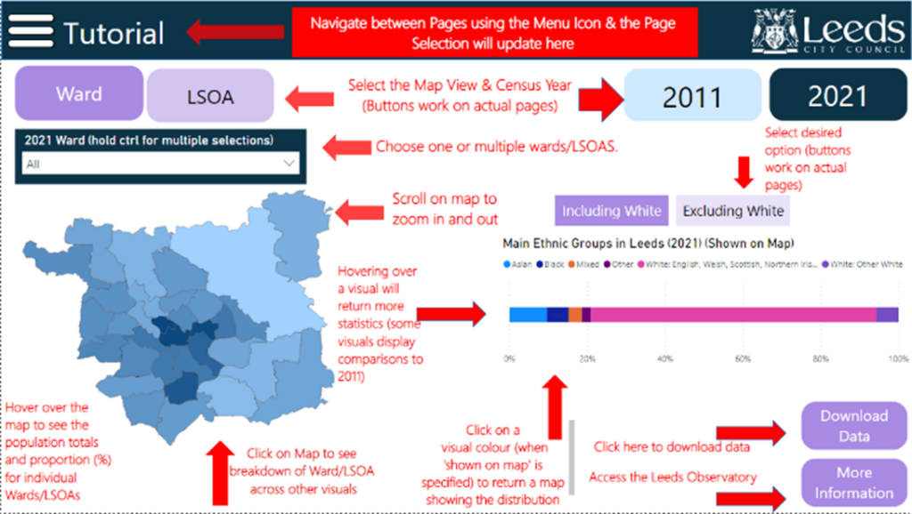
Figure 1: Screenshot of the Tutorial page in the census dashboard. This page has text and arrows explaining how to use each section of the dashboard.
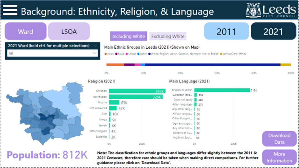
Figure 2: Screenshot of the Background: Ethnicity, Religion, & Language page in the census dashboard. This page has a map of Leeds (which returns a choropleth of ethnicity). It has three bar charts demonstrating Ethnicity, Religion and Language. It is interactive, where a user can click on the map or select a Ward or LSOA which returns the statistics for that area in 2011 or 2021. Tooltips (Pop-ups) appear on every visual providing more information.
Case Study: Is it possible to nudge consumers towards making healthier swaps when shopping in-store via signposting?
Project overview
The United Kingdom is estimated to lose 1.5 million years of healthy life to diet-related illness, disease, and premature death each year (1).
The retail food environment plays an influential role in influencing consumers’ diets, with most of the UK populace carrying out their grocery shopping in large supermarket retail chains (2). In recognition of this, studies have been conducted to examine various methods in which consumers can be nudged towards healthier and more sustainable choices at the point of purchase. One way to do this is by running swap interventions, where the trial participants are encouraged to select a healthier alternative to the option in their baskets. However, many swap intervention trials have been set in online experimental supermarkets (3-7) which were noted to have higher swap acceptance rates than when the intervention was carried out in a real-life setting (8).
This project aimed to investigate if in-store signposting would be able to nudge customers to make a healthier swap between two comparable products, across eight product pairs.
Data and methods
The trial occurred countrywide in February 2021 and focused on eight product pairs, consisting of an original product and a ‘healthier’ alternative across the following categories: cereal, cheese, chicken, coleslaw, fries, granola, rice, and tuna. The trial products were selected to ensure that they offered a ‘healthier’ nutritional profile in that they contained lower (or equal) levels of the ‘less healthy’ nutrients such as saturated fat or sugar and higher (or equal) levels of the ‘healthier’ nutrients e.g., dietary fibre.
Product category
Original product
Healthier swap
1. Fries
Curly fries
Crinkle cut fries
2. Chicken
Chicken Kiev
Breaded chicken
3. Cereals
Frosted Flakes
Honey Loops
4. Tuna
Tuna in Sunflower Oil
Tuna in Spring Water
5. Rice
Long grain white rice
Long grain brown rice
6. Granola
Fruit and nut granola
Low sugar granola
7. Cheese
Grated cheddar
Light grated cheddar
8. Coleslaw
Creamy coleslaw
Reduced fat coleslaw
Figure 1: A table showing the original product and the healthier swap offered within the same category
For the trial data, we received basket-level sales for a 12-week pre-intervention period, a 4-week trial period and a 12-week post-trial period. We also received data for the same period for 2018/2019 and 2019/2020 to get a better understanding of usual purchasing trends in the absence of the trial. We analysed data from two regions in the north and south of the UK determined by the retailer’s distribution areas.
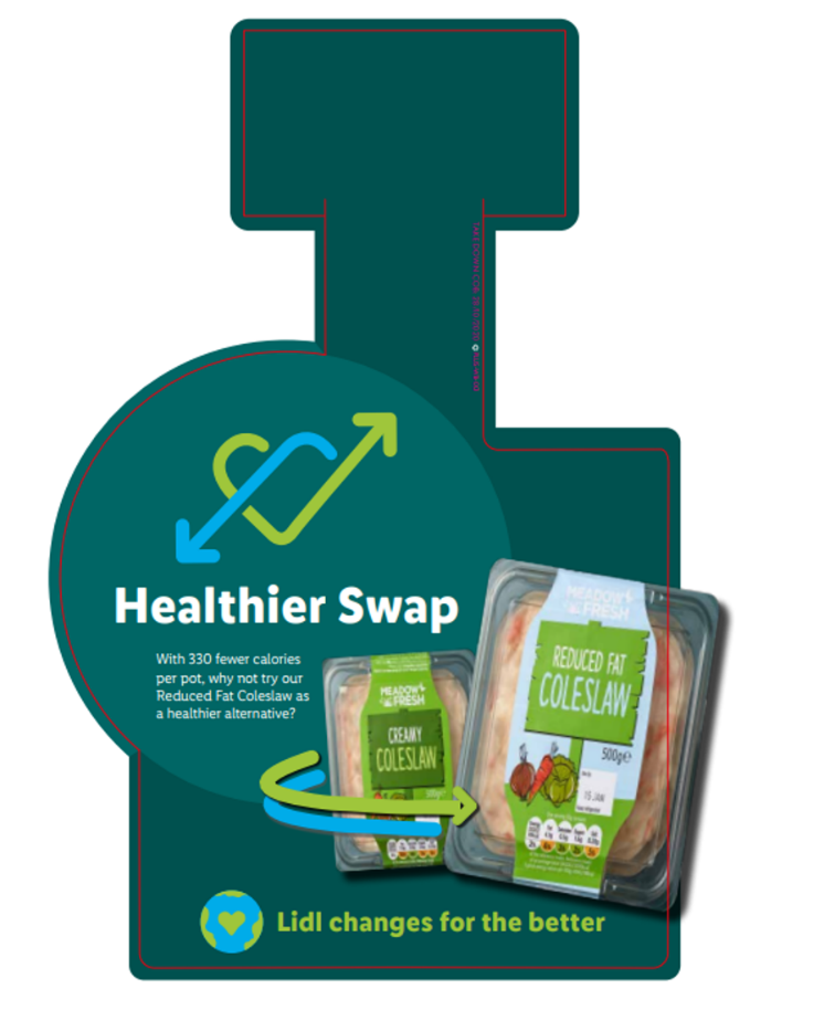
Figure 2: An example of the wobblers used in store. The wobblers were designed to sit on shelf and protrude out to attract attention.
This wobbler shows the original product, the creamy coleslaw and its healthier alternative, the reduced fat coleslaw with a message encouraging customers to swap for the reduced fat coleslaw as it has 330 less calories per pot.
Our approach to analysing this data was to use interrupted time-series analysis to predict the sales in the trial period if the trial had not taken place (our counterfactual). The absolute and relative effects were then calculated by comparing the predicted value to the actual sales, with effectiveness determined at the 95% significance level.
We also conducted an Eatwell analysis on the baskets to track how well the baskets are aligned with the Eatwell guide (the UK diet recommendation), and whether this changed because of the trial. To achieve this, products were matched to segments of the Eatwell guide using a text matching algorithm (9) that was altered to better fit the retailer.
Key findings
During the analysis, the success of the trial was defined as seeing an increase in the sales of the healthier swap, and no change or a decrease in sales of the unhealthier swap when compared to predicted sales based on previous purchasing behaviour.
During the trial period, the sales of the healthier swap for the cereals (32.37%) and coleslaw (71.47%) increased significantly, while sales of the original product remained stable. These products had messaging on sugar and calorie reduction respectively, which have been found to be high on shoppers’ health priorities (10) . Therefore, it could be hypothesised that the messaging resonated more with the customers.
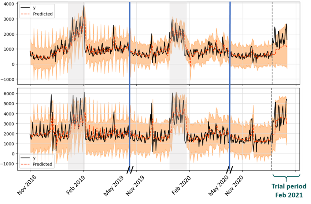
Figure 3: Two interrupted time series analysis graphs showing the predicted results for the reduced fat coleslaw (top) versus the original product coleslaw (bottom).
The grey bands indicate the matched trial period in the previous two years, while the blue line indicates the time gap between the post-trial periods and the pre-trial periods. The orange dotted lines show the predicted sales by the model, while the solid black line shows the actual sales of the two coleslaw products. The actual sales for the reduced fat coleslaw (top graph) are significantly higher than the predicted sales during the trial period.
For fries, rice and cheese, the sales of both the healthier and the original product increased during the trial. This implies that the signposting acted as a cross promotion and brought attention to both products, thus leading to an increase in sales. This could be problematic if it means that customers purchase a higher number of calories overall as a result of the signposting bringing attention to a product they had not considered purchasing and influencing them to buy the product. The messaging for these three products focused on fat (fries and cheese) and fibre (rice) which shoppers report as less important, according to survey data (10). Interestingly, despite increased sales in both variants, there was a greater increase in the sales for the healthier swap (90.71%) when compared to the original product (32.58%) for fries. This might mark fries in general as an easy entry point to encourage people to try a healthier version as they would assume that since the product is still a bag of potato fries, the taste would not be affected – making the jump easier.
Lastly, for the chicken, tuna and granola, the trial had no impact on the sales of the healthier product. Shoppers might be more resistant to swaps offered in protein-based meal centres like meat and fish which typically have a higher price point, as suggested by a study by Forwood et al. on online swaps (3). For the granola, the sales of the original product were higher than predicted, suggesting the trial had unintended consequences of encouraging customers to buy the less healthy variant. This could be because fibre messaging is associated with a negative trade-off with flavour (11), furthermore the healthier granola was a relatively new product and may not yet have been fully adopted by the customers.
Value of the research
This research shows that signposting can be used to nudge customers to make healthier choices by offering swaps which provide a more manageable option for people who wish to eat healthier but do not know where to start. However, differences in success by product type suggest more work is needed to unpick customer motivations and identify suitable categories and messages to encourage swaps. The type of nutrient targeted in the messaging plays a larger role in influencing the customer as it was observed that sugar and calorie messaging were more successful in the trial in comparison with the fat and fibre messaging.
Quote from project partner
“When developing this trial, we wanted to understand how best to help our customers make healthier choices at point of sale, where we know they make decisions.
This trial has demonstrated the importance of product choice and types of messaging used. Going forward, we plan to continue testing what works around signposting, in collaboration with University of Leeds and IGD, to help customers eat healthier.”
LIDL, GB
Insights
Signposting can be used to promote healthy swaps.
Signposting could lead to cross-promotion.
Clear messaging is essential to prevent unintended consequences.
People
Rayan Onyonka, Leeds Institute for Data Analytics
Victoria Jenneson, School of Medicine, and Leeds Institute for Data Analytics
Michelle Morris, School of Medicine, and Leeds Institute for Data Analytics
William Young, School of Earth and Environment and Leeds Institute for Data Analytics
Partners
Institute of Grocery Distribution
LIDL GB
Funders
Funded by Institute of Grocery Distribution with support from the Consumer Data Research Centre.
References
1. National Food Strategy. National Food Strategy. 2021.
3. Forwood, S.E., Ahern, A.L., Marteau, T.M. and Jebb, S.A. Offering within-category food swaps to reduce energy density of food purchases: a study using an experimental online supermarket. Int J Behav Nutr Phys Act. 2015, 12, p.85.
4. Koutoukidis, D.A., Jebb, S.A., Ordonez-Mena, J.M., Noreik, M., Tsiountsioura, M., Kennedy, S., Payne-Riches, S., Aveyard, P. and Piernas, C. Prominent positioning and food swaps are effective interventions to reduce the saturated fat content of the shopping basket in an experimental online supermarket: a randomized controlled trial. Int J Behav Nutr Phys Act. 2019, 16(1), p.50.
5. Payne Riches, S., Aveyard, P., Piernas, C., Rayner, M. and Jebb, S.A. Optimising swaps to reduce the salt content of food purchases in a virtual online supermarket: A randomised controlled trial. Appetite. 2019, 133, pp.378-386.
6. Bunten, A., Porter, L., Sanders, J.G., Sallis, A., Payne Riches, S., Van Schaik, P., Gonzalez-Iraizoz, M., Chadborn, T. and Forwood, S. A randomised experiment of health, cost and social norm message frames to encourage acceptance of swaps in a simulation online supermarket. PLoS One. 2021, 16(2), p.e0246455.
7. Jansen, L., van Kleef, E. and Van Loo, E.J. The use of food swaps to encourage healthier online food choices: a randomized controlled trial. Int J Behav Nutr Phys Act. 2021, 18(1), p.156.
8. Stuber, J.M., Lakerveld, J., Kievitsbosch, L.W., Mackenbach, J.D. and Beulens, J.W.J. Nudging customers towards healthier food and beverage purchases in a real-life online supermarket: a multi-arm randomized controlled trial. BMC Med. 2022, 20(1), p.10.
9. Potin, F. FrancescaPontin/Eatwell_product_classification: Version 1.0. Zenodo. 2022.
10. Institute of Grocery Distribution. IGD ShopperVista research. October 2022.
11. Raghunathan, R., Naylor, R.W. and Hoyer, W.D. The Unhealthy = Tasty Intuition and Its Effects on Taste Inferences, Enjoyment, and Choice of Food Products. Journal of Marketing. 2006, 70(4), pp.170-184.
Case Study: Developing a digital twin of a retail loyalty scheme
Developing a proof-of-concept digital twin of a retail loyalty scheme to simulate customer behaviour change in response to incentives.
Project overview
Increases in the cost of goods caused by disruptions to the global supply chain have led to an ongoing cost-of-living crisis and there are growing calls on businesses such as retailers to do more to support consumers who may be vulnerable to price increases (Which?, 2022).
Customer loyalty schemes offer benefits to both customers and businesses including the ability to nudge purchasing behaviours towards more sustainable, affordable, or healthier goals. In addition, modern data infrastructure and technology offers the ability to make data-driven business decisions relating to loyalty schemes.
In collaboration with a large retailer, this work develops a proof-of-concept (PoC) digital twin of a customer loyalty scheme consisting of an agent-based model (ABM) to generate synthetic purchasing scenarios from consumer agents. The model is integrated with a cloud-based Digital Twin platform which enables the analysis of simulation outputs by multiple users through graph-based queries.
The goal of the project was to create a PoC system capable of exploring ‘what-if’ scenarios relating to the retailer’s loyalty scheme to assess the impact of including certain products within the scheme.
Data and methods
We collaborated with our retail partner’s Decision Science & Analytics team to develop the PoC. They use Microsoft Azure for operational data stores and other services, hence to support model initialisation and integration with existing business practices (e.g. reporting pipelines), the simulation system utilises the Azure Digital Twins (ADT) service. The ABM back-end uses the open-source Mesa agent-based modelling framework and feeds into the digital twin via the Python Software Development Kit (SDK). The digital twin uses a graph database to capture the current state of a running simulation. The ABM consists of distinct customer agents together with a purchasing model that depends on attributes of each customer agent and a sample product database.
On model initialization, customer agents are instantiated from customer segments, defining store visit frequency and receptiveness to promotions. On each time step, customers decide whether to visit the store, based on a probability distribution informed by customer segments. The set of available products is matched via product attributes to customers’ preferences, and these are combined to form a contextual purchase intention for each product (Doniec et al., 2020). This is then used to construct a basket for each customer per visit. Important model factors that lead to emergent dynamics within the simulation include product affinities, which influence the attractiveness of products based on items already within a basket and, importantly for our research question, the influence of promotions delivered via the loyalty scheme. Combining product affinities with the impact of promotions supports ‘what-if’ scenarios where a promotion of Product A via the loyalty scheme leads to an uplift or drop in sales for Product B, depending on the associated affinity between the two products.
Key findings
The primary outcome of the project is the PoC system comprising of an ABM integrated with Azure Digital Twins, capable of exploring what-if scenarios in relation to the loyalty scheme. We have demonstrated the PoC system exhibits representative customer behaviour in response to the promotion of products within a sample catalogue. The following describes an example.
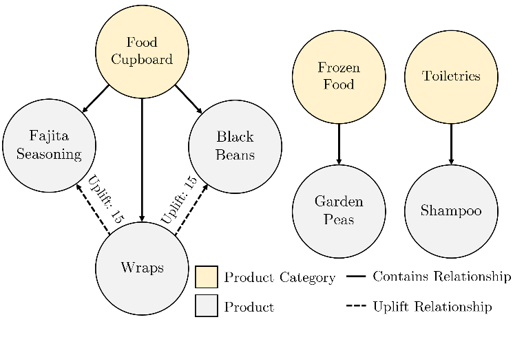
A sample product catalogue, shown in Figure 1, was set up in ADT’s graph database. The sample catalogue contains five products: fajita seasoning, wraps, black beans, garden peas, and shampoo. The sale of wraps is associated with an uplift in the sales of fajita seasoning and black beans. This is captured by product-product relationships shown in Figure 1 (dashed lines).
Figure 1: Example product catalogue graph set up in Azure Digital Twins
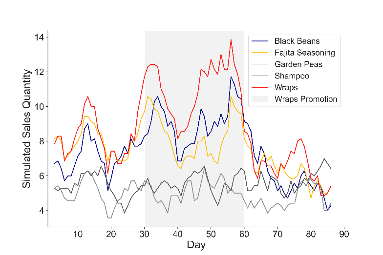
Simulated sales were generated via agent purchases from the sample catalogue. From day 30 to 60 of the simulation, wraps were placed on promotion as shown by the grey region withinFigure 2. The model captures an increase in wrap sales (red) driven by the customer agent segments most receptive to promotions. This sales increase is also apparent for the associated products, black beans, and fajita seasoning (blue and yellow), as they are commonly bought together. As the model runs, simulated transactions made by customer agents are written to ADT.
Figure 2: Output simulated sales quantities (seven-day rolling average) for 200 customer agents over 90 days for the example product catalogue
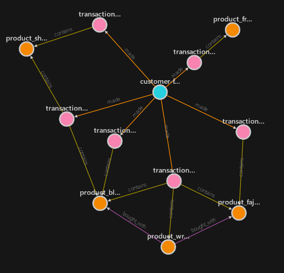
The resultant transaction graph for a single customer agent is displayed in Figure 3. The agent (blue) has made five transactions (pink) over the simulation period. Each transaction possesses relationships to the products purchased (orange). Multiple users can simultaneously analyse the resultant customer-transaction graph through graph-based queries.
Figure 3: Output ADT graph for a single customer agent over a 90-day simulation period for the example product catalogue
Documentation for the system was prepared covering its ABM, integration with Azure Digital Twins, and a walkthrough of conducting simulations using the PoC. This was shared with our retail partner, alongside the codebase, to support their continuation of the project.
Value of the research
The integration of ABM with an enterprise graph database capturing product affinities offers significant potential for the answering of deeper, more complex ‘what-if’ questions in relation to customer loyalty schemes. This supports the optimisation of loyalty schemes towards desired outcomes, such as healthier or more sustainable consumer purchasing.
The PoC digital twin contains a framework for simulating purchasing behaviour under the influence of a loyalty scheme; a foundation from which the system can be developed, and further value realised. Integration with our partner’s existing customer segmentation database would enable timely updates to the model as customer segments evolve. Integration with customer and product feature stores would enable the creation of more realistic, nuanced agents improving the simulation further. Multi-order product affinity relationships, where purchasing Product A influences the purchase of product B which in turn influences product C, could be captured and utilised in the system. This would likely lead to further emergent behaviour generating valuable insights into the knock-on effects of promotion decisions.
Insights
Bridging the gap between agent-based modelling and digital twins
Integrating agent-based modelling with enterprise data infrastructure
Exploring ‘what-if’ scenarios relating to customer loyalty schemes
People
James Battye – Data Scientist, Leeds Institute for Data Analytics, University of Leeds
Dr Peter Baudains – Research Data Scientist, Consumer Data Research Centre, University of Leeds
Dr Jonathan Ward – Lecturer, School of Mathematics, University of Leeds
Partners
NDA applies
Funders
Consumer Data Research Centre
References
Which? 2022. Affordable food for all: how supermarkets can help in the cost of food crisis. Site. [Online]. [Accessed 3 April 2023]. Available from: https://www.which.co.uk/policy/policy/consumers/9142/affordable-food-for-all-how-supermarkets-can-help-in-the-cost-of-food-crisis.
Doniec, A., Lecoeuche, S., Mandiau, R. and Sylvain, A. 2020. Purchase intention-based agent for customer behaviours. Information Sciences. 521, pp.380–397.
The out of home food industry plays a key role in people’s diet, with demand for online delivery on the rise and adoption of new technologies having increased due to the Covid-19 pandemic. Understanding how people are using online food delivery platforms will go a long way to help us understand developing food behaviours and the digital food environment.
Project overview
In a first of its kind partnership with an online food delivery provider, we have looked at consumer transaction records for online food purchases and how they correlated to census demographic characteristics from the 2021 release.
Data and methods
We used customer transaction data which was provided by a large online food delivery platform, which included a unique customer, order and restaurant identifiers; postcode for the order, delivery, and restaurant; transaction value; primary and secondary restaurant cuisine; order dates; amongst others.
Customer demographics were estimated from census 2021 release at the output area level by matching customers to an output area using order postcode information.
Initial exploratory analysis included summary statistics and Pearson’s correlation of order frequency, median basket price, and different census characteristics.
Different machine learning methods were explored to model consumer behaviour and consumer profiles of order frequency and expenditure including K-means clustering, hierarchical clustering, Ordinary Least Squares (OLS) regression, Principal Components Regression and Partial Least Squares Regression.
Key findings
We explored consumer trends in delivery take away ordering at the output area level (100-250 households) by calculating Pearson’s correlation between median basket price and order density and 2021 census variables.
We found that markers of affluence were generally positively associated with median basket spend, whereas they were negatively associated with order frequency. The opposite is also true for markers of deprivation or low economy. We investigated the opposite relationship between median basket spend and order density in Leeds and compared it to the geo-distribution of socio-economic status in Leeds.
We found a north-south divide across Leeds where general areas of high order frequency had lower median basket spend, and they coincided with output areas which had high number of lower socio-economic status households.
We explored the food preferences of high and low median basket spend and order frequency and found that high order frequency and low median basket spend were positively associated with restaurants which primary cuisine type was described as burgers, and negatively correlated with more expensive cuisine types such as Indian or Chinese.
We successfully modelled median basket spend per output areas, explaining 50 percent of the median basket spend, and saw that average car availability per household had the strongest effect in predicting median basket price (30 percent increase in basket price for every 1 unit increase in average car availability). Output area classification was the second most predictive variable.
Value of the research
In 2020, 41 percent of all out of home food expenditure was on food delivery, and the out of home food market is set to continue growing. There is a growing interest in understanding how people make food choices, and this has been difficult due to poor understanding of how consumers are utilising such platforms.
With this piece of research, we are able to understand the demographic profile of online food delivery users. We have also gained an insight into the digital food environment and the factors that affect it. In particular, we have found car ownership to be very strongly associated with usage of online food delivery services. This is an important finding that could be pointing towards an access factor. Further research could investigate this matter to improve access to supermarkets in areas with low car availability.
We suggest that affluence is a major factor in out of home delivery usage, with more affluent populations ordering more expensive cuisine at lower frequencies, whereas low economy areas have a more frequent ordering behaviour with a lower general spend.
The demographic factors that signal affluence are complex, however. Although we have seen some association between them, how these interplay to affect median basket price is still unknown. We have found that affluent areas with higher rates of car access have lower ordering frequency, however, this is not a measure for out of home food consumption as this study is limited to food which is ordered for delivery. A wider study might look at all out of home food orders and understand the relationship between delivery and collection orders.
Insights
Output areas with high percentage of high skilled workers and higher managerial occupations show lower order frequency.
Output areas with a higher percentage of older and retired populations are associated with higher median basket price.
Populations which show a higher order frequency seem to be more likely to order burgers from chain restaurants, whereas populations with higher median basket spend are more likely to order Chinese or Indian cuisine.
Access measured by car availability and affluence are the most predictive factors in forecasting basket price.
People
Tamara Garcia del Toro, Data Scientist, LIDA
Francesca Pontin, Research Data Scientist, Consumer Data Research Centre
Rachel Oldroyd, Lecturer, School of Geography
Nik Lomax, Professor, School of Geography & Consumer Data Research Centre
Stephen Clark, Research Fellow, Consumer Data Research Centre
CDRC researchers to conduct first-ever evaluation of HFSS legislation as part of DIO-Food Project
In October 2022, legislation came into effect in England that restricts promotion of products High Fat, Sugar or Salt (HFSS) by in-store and online location.
Beginning a year on from the legislation’s implementation, a team of CDRC researchers led by Professor Michelle Morris, will run analysis using population-level supermarket transaction data provided by three different retailers to evaluate the impacts of HFSS legislation.
This analysis run as part of the DIO Food project, will be the first-ever evaluation of this legislation and comes ahead of proposed implementation in the devolved nations, providing a unique opportunity to conduct an analysis of the impacts for retailers ahead of any new policy changes across the UK.
The sales data provided by the retailers will be for stores selected across deciles of our Priority Places for Food Index (developed in collaboration with Which? in 2022) to allow us to investigate whether the legislation has impacted different communities equally.
The researchers will analyse the impacts of the implementation from a health and sustainability perspective, using dietary (Eatwell Guide) and environmental metrics developed with IGD and their Industry Nutrition Strategy Group (INSG).
The team will also use innovative data products created by CDRC’s Dr Fran Pontin (Eatwell algorithm) and Dr Victoria Jenneson (Nutrient Profile Model Calculator) in their analysis, providing insight to retailers that cannot be found elsewhere.
Prof Michelle Morris, School of Food Science and Nutrition at the University of Leeds commented:
“In addition to the quantitative sales data work, we’ll also be doing some qualitative analysis through interviews and focus groups with different stakeholders, including policymakers, the retailers themselves and importantly members of the public.”
The qualitative work will be led by CDRC Research and Impact Manager, Dr Emily Ennis.
We are looking forward to learning more from this interdisciplinary, cross sector team of Morris, Jenneson, Pontin, Ennis and Dr Alison Fildes from the School of Psychology at University of Leeds alongside retailers, the IGD and wider DIO Food team.
More about the DIO Food Project
This pilot will be run as part of the Diet and Health Inequalities (DIO Food) project at the University of Aberdeen – The goal of the DIO Food project is to identify how we can provide timely evidence-based research and commentary from those facing diet and health inequalities. The main focus of the project is working with vulnerable groups (early years and people with low income) to tackle the cost-of-living crisis to give timely policy directives.
DIO Food is an add on research activity to the Food Insecurity in people living with Obesity (FIO Food) which aims to provide actionable evidence for policy on retail strategies to address dietary inequalities in people living with obesity and food insecurity, to support sustainable and healthier food choices in the UK food system.
Encouraging Healthy and Sustainable Diets through Cross-Sectoral Partnerships
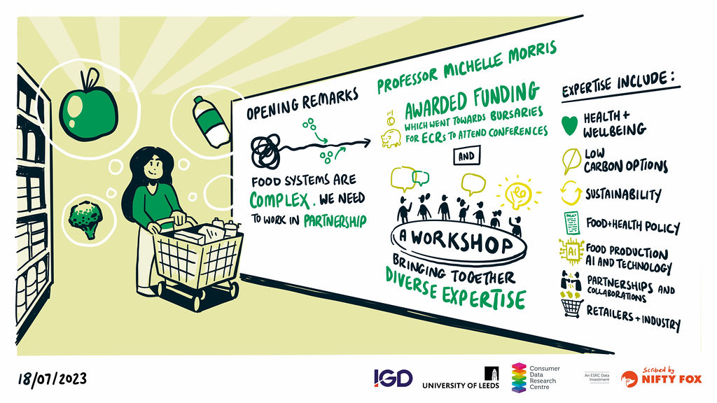
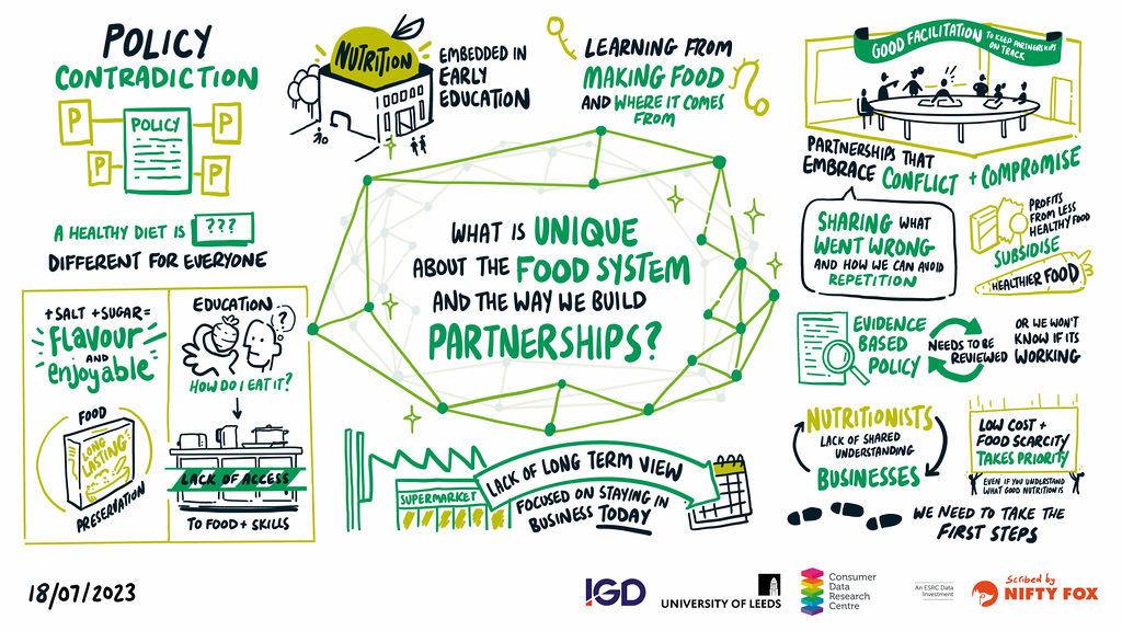
We were delighted to host colleagues from a variety of disciplines and functions at the University of Leeds, the charity sector, industry representatives and local government at the Leeds Institute for Data Analytics on the 18th July 2023.
We came together for a workshop to discuss “Encouraging Healthy and Sustainable Diets through Cross-Sectoral Partnerships”.
The aim of the workshop was to better understand what makes a good partnership for research across the food system with a key objective to create a shared resource to promote and share lessons on partnership working.
Specifically, we discussed two main questions:
1 – What is unique about the food system and the way we build partnerships?
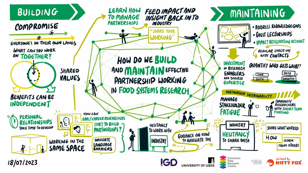
2 – How do we build and maintain effective partnership working in food systems research?
The complexity, breadth and depth of food system research mean that cross sectoral partnerships are even more essential to facilitate research that can drive change, however it also means that focused discussions are challenging too. With that in mind, we put some guide rails around the discussion, which were to focus on the consumer facing part of the food system. After all, we are the Consumer Data Research Centre!
We are grateful to the University of Leeds Engaged for Impact awards who celebrated our work building networks with supermarkets to assess healthy and sustainable consumer diets, in collaboration with the IGD (Institute of Grocery Distribution). The prize money facilitated the running of this workshop, and has additionally provided important bursaries for early career colleagues to attend conferences to build their own networks and partnerships. We were awarded this prize for our work in the area of building Partnerships and Networks and wanted to make sure that we were able to develop our own ways of working by learning from others, but also capture and share learnings in an accessible way to a wider audience.
The workshop was convened by Prof. Michelle Morris, Professor Data Science for Food and CDRC Co-I and Dr Emily Ennis, CDRC Research and Impact Manager. The delegate expertise spanned health and wellbeing, sustainability and low carbon, food and health policy, food production, AI and technology, partnerships and collaboration, retailers and industry and more.
It was our pleasure to welcome Chris Redford from NiftyFox to the workshop who skilfully captured our discussions so well through live scribing.
What is unique about the food system and the way we build partnerships?
We reflected on the complexity of the food system which is highlighted by the large number of government departments with responsibility for food, including, but by not limited to: the Food Standards Agency; Department for Environment, Food and Rural Affairs; Department for Health and Social Care; Office for Health Improvement and Disparities; Department for Business and Trade.
Given the breadth of the food system we often lack a shared language and even shared definitions of concepts like ‘a healthy and sustainable diet’. We encounter challenges from the commercial nature of much of the food system and the need for a pre-competitive space to share learnings. The food sector is turbulent which often means that there is a culture of firefighting, rather than long term planning. This is contrary to local (and national) government which have long horizons. This can result in a disconnect within the food system. The sector needs to respond rapidly to system shocks like Brexit, the covid-19 pandemic, war in the Ukraine and the cost-of-living crisis. In light of all of this collaborations should expect to need to overcome conflict which likely leads to inevitable compromise if we are to move forwards.
We discussed the tricky matter that nutrition is not always respected as a science. Many celebrities masquarade as nutrition experts, without the appropriate qualifications. This makes it harder for qualified and registered nutritionists to be heard and make an impact. Currently there is a voluntary register for Nutritionists managed by the Association for Nutrition, with the vision to achieve chartered status for the profession.
Food is something required by everyone. It is more than a fuel to stay healthy, it is indicative of different cultures, it is a pleasure, it is a career, it needs to be safe which requires understanding and education. It also costs money, and this means that it is a focal point of our current cost of living crisis and will be at the heart of inequalities for years to come if unchecked.
It is a combination of all of this that makes the food system different to other areas and industries and impacts upon how we collaborate.
How do we build and maintain effective partnership working in food systems research?
The essence of this discussion was about finding the shared value from the collaboration, where all parties benefit. This requires listening, sometimes compromising and investing time in building a trusted partnership and then dedicating time to maintaining the partnership.
At times we just need to jump in with both feet and start a collaborative project. We may need to start small, but the process of working together to a shared goal will allow the partnership to grow and generate evidence which will demonstrate the need for further investment.
Often collaborations come down to the people involved, and it is important to share the learnings from personal experience and relationships with early career colleagues. We need to ensure that we teach and share the ways of working, going beyond the technical skill development, but including the alpha skills that will stand them apart in the future. These colleagues are the key to maintaining relationships longer term. The development of the next generation needs to happen across all the organisations involved in the partnership working. We discussed many ways in which this could happen, including shared spaces for working, secondments and specific investment in capacity building.
Caution is needed with regards to stakeholder fatigue, for research partners, be-it industry, policy makers or the third sector, collaborating with academics is unlikely in their job description, they go over and above for things they are passionate about. We also need to be mindful of reputation, not all academic disciplines aligned to the food systems are accepting of collaboration with industry. We need to support colleagues to manage ways of working that do not compromise academic integrity.
Timelines are important and these vary depending upon the partner, these should be discussed up front and expectations managed and ways of working adapted accordingly.
This workshop has created shared learnings generated from all twenty delegates. It has additionally extended the delegates’ networks, many of whom met for the first time at this workshop. We plan to share the images from this blog widely to support future food system collaboration and partnerships to encourage healthier and more sustainable diets, please help us with that.
You are welcome to re-use these images, but please include the following acknowledgement:
“Thanks to all participants at the Healthy and Sustainable Diets Partnership Workshop at the University of Leeds on Tuesday 18th July 2023, whose contributions are represented in these images. The workshop was funded by a University of Leeds Engaged for Impact Prize and convened in collaboration with the Consumer Data Research Centre (Leeds). Artwork Scribed by NiftyFox https://www.niftyfoxcreative.com/”
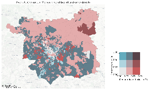
Which? highlights neighbourhoods in Wales most at risk of food insecurity
Consumer group Which? have used our Priority Places for Food Index to highlight the neighbourhoods in Wales most in need of support to access food during the current cost of living crisis.
As part of their recent Policy research paper – Consumers in Wales – a food briefing – Which? explored and highlighted the Priority Places in Welsh Senedd Regions.
Region
Total number of neighbourhoods
Proportion that are priority places
Why are neighbourhoods in this region classed as priority places?
Mid and West Wales
346
15%
Overall, neighbourhoods in Mid and West Wales tend to have relatively worse supermarket and non-supermarket proximity and poor online delivery access. The priority places in this region are particularly characterised by poorer than average supermarket proximity and supermarket accessibility.
North Wales
385
12%
There are higher levels of fuel poverty in North Wales. Neighbourhoods in this region that are priority places tend to have higher socio-economic barriers.
South Wales Central
439
20%
Neighbourhoods in South Wales Central score relatively well across many factors and around the national average for family food support and socio-demographics. Priority places in this region have particularly high levels of fuel poverty, higher socio-demographic barriers and poor online delivery access.
South Wales East
404
32%
South Wales East has a disproportionately high number of priority places and this is driven by a high need for family food support.
South Wales West
335
19%
Overall, areas in South Wales West are around the national average or higher. Priority places in this region are characterised as having high levels of fuel poverty and high need for family food support.
Note: Which? Analysis of the Priority Places for Food index. LSOAs (Lower Super Output Areas) are matched to constituencies and regions using a best-fit approach. Neighbourhoods i.e. LSOAs are matched to the constituency where the highest proportion of the neighbourhood’s population falls into. The population estimates are based on the city and town classification analysis.
What is a priority place for food?
Priority places are neighbourhoods most at risk of food insecurity, and where interventions to help people access affordable food will be most valuable.
There are many reasons why people may find it difficult to access affordable food.
Some relate to individuals’ circumstances, like lower incomes. Other reasons relate to the place that someone lives, such as the level of retail provision or the quality of public transport. In the case of accessing affordable food online, barriers may be both place-based (limited or no online deliveries) or related to the individual (limited capability to shop online).
Which? is calling on Supermarkets and the Welsh and British Government to help those most at risk of food insecurity – find out more and read the full report.
What is the Priority Place for Food Index?
The Priority Places for Food Index – developed by Dr Michelle Morris, Dr Pete Baudains and Dr Fran Pontin in collaboration with Which? – is a composite index formed of data compiled across seven different dimensions relating to food insecurity for the four nations in the UK. It is constructed using open data to capture complex and multidimensional aspects of food insecurity.
Building on the CDRC e-Food Desert Index, from Dr Andy Newing, but with additional domains relating to fuel poverty and family food support, the goal of the Priority Places for Food Index is to identify neighbourhoods that are most vulnerable to increases in the cost of living and which have a lack of accessibility to affordable, healthy, and sustainable sources of food.
The index is developed at the geographic level of Lower Super Output Areas in England and Wales, Data Zones in Scotland and Super Output Areas in Northern Ireland (2011 boundaries). Data for all countries is included where possible, but some indicators are not available across all countries.
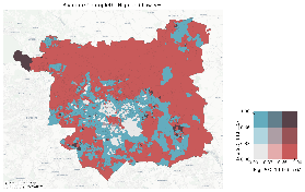
Where are the Priority Places for Food in Scotland?
Consumer group Which? have used our Priority Places for Food Index to highlight the neighbourhoods in Scotland most in need of support to access food during the current cost of living crisis.
As part of their recent Policy research paper – Consumers in Scotland – a food briefing – Which? identified ten Parliamentary Constituencies where over half of the neighbourhoods are a priority place.
Constituency Name
Neighbourhoods in constituency
Proportion of neighbourhoods that are priority places
Rank (out of 73 Scottish parliamentary constituencies)
Cunninghame South
92
71%
1
Cunninghame North
94
69%
2
Glasgow Provan
98
68%
3
Greenock and Inverclyde
107
62%
4
Glasgow Pollok
101
61%
5
Kilmarnock and Irvine Valley
108
60%
6
Glasgow Anniesland
92
57%
7
Glasgow Maryhill and Springburn
90
53%
8
Dumbarton
102
52%
9
Dundee City West
94
51%
10
Note: Which? Analysis of the Priority Places for Food index. Data Zones 2011 are matched to Scottish Parliamentary constituencies and electoral regions using 2011 Data Zone Lookups from statistics.gov.scot.
What is a priority place for food?
Priority places are neighbourhoods most at risk of food insecurity, and where interventions to help people access affordable food will be most valuable.
There are many reasons why people may find it difficult to access affordable food.
Some relate to individuals’ circumstances, like lower incomes. Other reasons relate to the place that someone lives, such as the level of retail provision or the quality of public transport. In the case of accessing affordable food online, barriers may be both place-based (limited or no online deliveries) or related to the individual (limited capability to shop online).
The Priority Places for Food Index – developed by Dr Michelle Morris, Dr Pete Baudains and Dr Fran Pontin in collaboration with Which? – is a composite index formed of data compiled across seven different dimensions relating to food insecurity for the four nations in the UK. It is constructed using open data to capture complex and multidimensional aspects of food insecurity.
Building on the CDRC e-Food Desert Index, from Dr Andy Newing, but with additional domains relating to fuel poverty and family food support, the goal of the Priority Places for Food Index is to identify neighbourhoods that are most vulnerable to increases in the cost of living and which have a lack of accessibility to affordable, healthy, and sustainable sources of food.
The index is developed at the geographic level of Lower Super Output Areas in England and Wales, Data Zones in Scotland and Super Output Areas in Northern Ireland (2011 boundaries). Data for all countries is included where possible, but some indicators are not available across all countries.
Before the pandemic, online grocery shopping was typically something younger and more affluent people living in cities indulged in. When COVID hit, though, the market exploded.
In the first week of the first UK lockdown, demand for Ocado home deliveries was reportedly ten times higher than it had been the week before. But when COVID restrictions were re-imposed in September 2020, the online supermarket, like its competitors, was still warning customers that slots were selling out fast. So fast, in fact, one staffer said they were going “like Glastonbury tickets.”
Households struggled to book delivery slots, as supermarkets rightly prioritised deliveries for elderly and vulnerable consumers. And retailers hustled to capitalise on this rapid growth.
In April 2020, Tesco told its customers it had hired 12,000 extra staff and 4,000 new delivery drivers. Six months in, Sainsbury’s said it was delivering 700,000 online orders per week, having effectively doubled its capacity.
In 2019, prior to the pandemic, my colleagues and I mapped online groceries coverage by all the major UK grocers, using the “check if we deliver to your area” tool on their websites. We found that where you live affects your choice and availability of online groceries.
People in rural areas have less access to supermarkets in general and, when it comes to online grocery shopping, just over 11% of those people have no choice at all.
Lack of choice
When households order groceries online from the major supermarkets, their orders are usually assembled in a local supermarket, what industry insiders term an “online fulfilment store”. These have dedicated staff, storage space, vehicles and drivers.
This model, however, means that online groceries are not available in all locations. Rather, they are concentrated around the network of stores that each grocer operates.
On each supermarket website we inputted one postcode from each of the 41,735 neighbourhoods in Great Britain – representing 25.7m households – and recorded the result. We then counted the number of retailers delivering to each neighbourhood.
We found that 98% of households in Great Britain are served by at least one of Tesco, Sainsbury’s or Asda. These three grocers offer the greatest delivery coverage, particularly in urban and suburban areas where households have a choice of grocer providing home delivery.
Other grocers have more restricted coverage. Iceland, a budget retailer with stores in urban areas, serves only 86% of households. Ocado, meanwhile, which is more upmarket and online only, delivers to only 77% of households.
Many neighbourhoods – in south-west and northern England, south and mid-Wales, and in Scotland’s borders, highlands and islands – suffer poor coverage of online groceries.
Households in many neighbourhoods in Argyll and Bute (Scotland), for example, have a single online groceries provider (Tesco). By contrast, in nearby Glasgow, most neighbourhoods have a choice of six online grocery providers.
Across Great Britain, we found that
over 11% of households in the most remote rural areas have no choice of provider. They must rely on a single grocer (typically Tesco) for online groceries.
Why retailers are not expanding into rural areas
Rural areas that are underserved by supermarkets in general are precisely those that could benefit the most from better online provision. In urban contexts, the older, higher spending consumer demographic was newly converted to online grocery shopping.
In rural areas, this same demographic could therefore represent untapped demand. In other words, there is an incentive for retailers to expand there.
Supermarket coverage across Wales is much thinner than for England.Llio Angharad/Unsplash
But that is not happening. We had rare access to data about the nationwide network of Sainsbury’s stores. Over 180 of those supermarkets are in London and south-east England, 85 of which are used as online fulfilment stores. This means the retailer is able to deliver groceries to all neighbourhoods in these regions.
In Wales, by contrast, there are only four Sainsbury’s online fulfilment stores concentrated around the major towns and cities in south Wales. We found that home delivery by Sainsbury’s was unavailable to 162,000 Welsh households (12%).
Even if all existing Sainsbury’s supermarkets in Wales were used for online deliveries, over 25% of neighbourhoods would still be more than 40km from their nearest fulfilment store. Drivers could have to travel over 100km to make their deliveries. This is prohibitively expensive and inefficient.
To expand online groceries coverage beyond the store network, retailers would need to fork out considerable sums to build more stores. Most, however, have cut back on supermarket expansion plans, focusing instead on smaller convenience stores to reflect changing shopper behaviours.
Amid changing consumer behaviours, online remains a key battleground for grocers. However, it offers lower profit margins than in-store shopping due to the higher costs of order preparation and delivery.
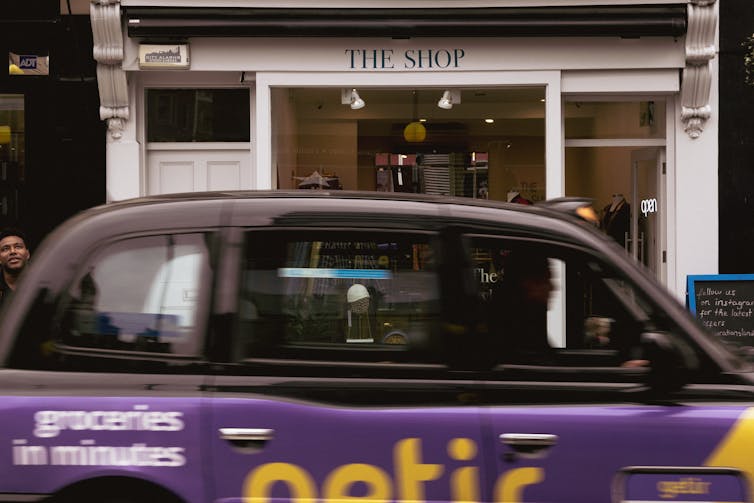
Will Turkish online grocer Getir expand into rural areas?Metin Ozer/Unsplash
Another solution is the partnership model between grocers and online platforms such as Uber Eats, Just Eat and Deliveroo, who collect customer orders from smaller convenience stores (such as Tesco Express).
New players like the Turkish online-only grocer Getir offer rapid delivery services using smaller, more efficient warehouses located close to the customers. However, these, too, are confined to urban areas, for now.
Not being able to choose where you shop has several adverse impacts. It can restrict competition in online groceries, which in turn can see customers faced with less choice of delivery slot or higher charges for home delivery.
And, as highlighted by the consumer choice champion Which? and the Consumer Data Research Centre, it can hamper access to affordable, healthy groceries, by limiting customers’ opportunity to shop around for the best deals and widest range.
Quite how this might change though boils down to whether the major grocers or the new innovators are able to make the investments needed to better cater to rural demand. Until then, customers in these areas will face the dual disadvantage of poor access to larger supermarkets and fewer online grocery options to improve things.