Home » footfall

Household mixing during COVID-19 lockdowns

Household mixing during COVID-19:
research suggests adherence to lockdowns in England declined over time

The grim prospect of COVID-19 stay-at-home orders is back in the news, with a number of European countries having either introduced new restrictions or reimposed full lockdowns amid rising cases. These developments inevitably raise questions around how we can best shape public health policy to reduce virus transmission.

One key challenge is reducing “risky” interactions between people, such as household visits indoors. We know close proximity and inadequate ventilation increase the chances of the virus spreading, leading to rising rates of illness. Yet our understanding of these household visitation behaviours, and the effectiveness of policy to reduce them, is lacking.

So in our latest research, we analysed mobility data collected from almost one million people in England between January 2020 and May 2021, seeking to understand trends in home visits during the pandemic.

This data was collected via location-based mobile phone apps by the data company Cuebiq, who obtained consent from users for their anonymised data to be used for research purposes. Working with Cuebiq we were able to generate aggregate analyses without obtaining any individual or household data (that is, none of the data we used could be linked to specific people).

Our interest here was in regional and national trends in mobility, and how populations moved around during the pandemic. For each region we developed indicators of visitation rates to residential areas outside of usual home areas, and assessed how these rates varied from baseline levels set in January and February 2020.

What we found

We saw a rapid reduction in people visiting other residential areas during the first lockdown in March 2020. The average decrease over the duration of the first lockdown was 39.3%, while at the lowest point, this activity was 56.4% below baseline levels. Rates of interaction increased prior to the end of the lockdown on May 12, and continued increasing through the spring and summer. But this was a gradual return.

The allowance of support bubbles in June 2020 brought no significant increase in home visits, although a flattening of the rate during August 2020 may indicate that social gatherings moved to restaurants during the operation of the Eat Out to Help Out scheme, or to public outdoor areas with warmer weather. While visitation rates exceed those seen in our baseline months, we can’t tell whether these were indoors or visits to front and back gardens, nor whether the rule of six was followed.

Later national lockdowns saw higher levels of mixing compared to what we observed in March 2020. The second lockdown in November 2020 saw a 15.3% reduction from baseline on average. Activity increased quickly after the end of the November lockdown, potentially due to the run-up to Christmas. The third lockdown, in January 2021, saw around a 26.2% reduction until mid-February.

We observed a significant rise in visitation from mid-February onwards while the third national lockdown continued – within two weeks rising to 23.3% above baseline levels. This increase in activity aligns with the announcement that the UK had offered vaccinations to the first four priority groups, which may have given people confidence to return to social activities at this time.

Graph showing trends in visits to other residential areas.
In this figure, the dots represent the daily mobility data, while the orange line represents a seven-day average. Scientific Reports, Author provided

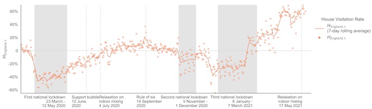
Taken together, the evidence suggests a slowly declining adherence to the stay-at-home rules as the pandemic went on. The underlying reasons for this will be multifaceted, summarised neatly as “lockdown fatigue”, but more precisely relate to increasing perceptions of safety in the face of the vaccine rollout, a need to re-engage in social activity, declining trust in government, and other personal stresses. These trends tell us we can’t simply pull the same policy leavers and expect to achieve the same outcomes as those seen in March 2020.

There is further variation in our findings when we look at different areas. In general, we observed lower levels of household visitation in rural areas, while some cities (London, Manchester and Cambridge, for example) regularly exceeded pre-COVID activity levels.

The reason for these differences is not clear. It could be linked to factors like household composition and personal circumstances, but further work is needed to better understand the complex demographic and household factors influencing these trends.

The implications

While there are some intriguing patterns of activity in this data, we must also apply plenty of caution in drawing conclusions. We can only speculate on the causes underlying the trends we observe, and the trends we see in England don’t necessarily reflect what has happened, or might happen, elsewhere.

Nevertheless, these findings add to our understanding of the impacts of pandemic policy, and highlight the need for nuance in crafting future interventions.

The patterns of household visitation we observed reflect the social complexities of the pandemic period. We must remember that household visitation does not equate to malicious noncompliance, and instead may point to the need for people to see each other for their emotional wellbeing.

While there are clear public health reasons to encourage caution in social mixing, this must be balanced against the negative outcomes of lockdowns and their potentially diminishing returns. Policy must be crafted to account for these nuances – supporting opportunities to socialise while avoiding higher risk interactions, responding locally, and adapting with the changing attitudes and circumstances faced by the population.


Ed Manley, Professor of Urban Analytics, University of Leeds and Mengdie Zhuang, Lecturer in Data Science, University of Sheffield

This article is republished from The Conversation under a Creative Commons license. Read the original article.

Measuring Ambient Populations during COVID-19 (Case Study)

Graph showing footfall data results

Measuring Ambient Populations during COVID-19 in Leeds City Centre
(Case Study)

The COVID-19 pandemic led to lockdowns being implemented all over the world, including in the UK.  The aims of the project were to investigate relevant data sources for modelling the ambient population of Leeds City Centre during COVID-19 and analysing the impacts that lockdown policies had on urban footfall.  The research builds on previous work undertaken with Leeds City Council by intersecting key dates from the English lockdowns and integrating these into machine learning models to assess the importance of different aspects of lockdowns. It also predicts what “business as usual” may have been like had there been no pandemic.

Analysis notebooks and scripts can be accessed at https://github.com/tbalbone31

Data and methods

Leeds City Council have been collecting footfall data for more than a decade. The data were wrangled and aggregated to create a history going back to 2008.  These data were then analysed alongside key lockdown dates to determine where trends in urban footfall intersected, raising questions about what aspects of these policies might have had the most impact.  The data cover a relatively small geographical area of Leeds City Centre and only reflect pedestrian traffic going past the locations identified by the cameras.  There are issues with data quality, such as potential double counting, periods of time with missing data and inconsistent file formatting, however it covers a large temporal scale and many problems can be worked around.

Google COVID-19 Community Mobility data was analysed as a potential alternative data source to the Council data.  It shows changes in mobility from a baseline for six different destinations (see the website for more details).  The smallest relevant spatial coverage is the Leeds City Region.  This was considered too large to isolate any changes impacting the city centre, making comparison of trends difficult.

The Council footfall data were resampled to show daily counts on which analysis was then conducted.  Visual analysis was undertaken to identify footfall trends over the course of the pandemic against key dates pertaining to the implementation and lifting of certain COVID-19 restrictions. These key dates were decided from research into when major legislation came into force or government announcements about restrictions were made.  The questions generated from initial analysis were then explored by creating a series of machine learning models using Random Forest Regression in the Python SciKit Learn package. 

The first model included a series of input variables to represent different aspects of society that had restrictions placed on them alongside other external conditions (such as weather, school/bank holidays, day of week, etc).  Variable importance was used to identify what (if any) aspects of lockdown might be significant in predicting future changes in footfall. The second model omitted any lockdown related inputs and was designed to make predictions on what “business as usual” might have been like had the pandemic not happened. 

Due to the inherently ordered nature of time series data, both models were validated using a method known as “Walk-Forward Validation” instead of the default Cross-validation included in SciKit Learn and often used on Random Forest Ensembles.  The implementation of Walk-Forward validation allows the model to be retrained after every prediction on the validation dataset, essentially “walking forward” through the time series.  This avoids potential data leakage because of the randomised nature of Cross-validation.

Key findings

The chart below shows the resampled footfall data intersecting with key dates from COVID-19 restrictions.

Key dates are shown as a dotted line with a number relating to a key.  Red zones indicate “official” lockdowns whilst orange represents periods where a variety of restrictions were in place but in the process of being lifted/introduced individually.  A summary of how this impacted footfall is below:

  • Footfall started to drop immediately after the announcement on 16th March 2020, no official restrictions implemented.
  • After non-essential shops and schools reopened on 15th June 2020, footfall started to rise again.
  • Footfall continues to rise through summer until around 22nd September 2020 when some restrictions were announced.
  • Footfall rises whilst Leeds is in tier 2 and 3, potentially because gatherings are only permitted in public spaces.
  • The second and third lockdowns drive footfall back down again until restrictions begin to ease again in April 2021.

The first machine learning model was intended to explore whether any lockdown variables would be significant in predicting future changes in footfall.  Variable importance (top 10) is shown below.

The most important lockdown-related features were indoor entertainment and non-essential retail.  Whilst this is only an initial model and not a definitive conclusion, it does help indicate what aspects of lockdown might have impacted pedestrian traffic in the city centre more than others.

The second model was designed to test how useful the data would be in predicting what “business as usual” may have been like.

There was little difference between error scores across different numbers of trees, so a compromise of the best score and least processing power (500 trees) was chosen.  The model predictions using this hyperparameter are shown below.

Results from this initial model are by no means definitive, however the potential to quantify how much footfall has been lost exists.  For example:

  • Average daily footfall in the lead up to Christmas (taken as 30th November to 24th December 2020) was approximately 36% lower than predicted.
  • Average daily footfall over the school holidays was approximately 63% lower than predicted.
  • Approximate footfall loss for individual Bank Holidays was also calculated.  Most recorded over 90% lower than predicted values except for the August Bank Holiday which was around 22% lower.

Value of the research

Initial analysis has already been delivered to Leeds City Council.  An aggregated dataset of footfall camera data has been created and is available on the Consumer Data Research Centre (CDRC) Data Store for future research.  The initial models developed can be used and refined by future researchers and develop more accurate predictions, whilst more specific time series packages can be explored.

Insights

  • Urban footfall and ambient population was significantly impacted by COVID-19 lockdown policies (as was intended).
  • Closure of Indoor Entertainment and Non-Essential retail appear to be the most important lockdown-related factors in predicting footfall change.
  • Consideration must be given to how time series data is processed in classic machine learning models such as Random Forests.

Research theme

Urban analytics

People

Tom Albone – Data Scientist Intern (LIDA)

Dr Nick Malleson – Professor of Spatial Science

Professor Alison Heppenstall – Professor in Geocomputation

Dr Vikki Houlden – Lecturer in Urban Data Science

Dr Patricia Ternes – Research Fellow

Partners

Leeds City Council

Funders

Consumer Data Research Centre

Towards a Better Understanding of Footfall


Since 2015 the Consumer Data Research Centre (CDRC) has worked with the Local Data Company to collect and analyse ‘SmartStreetSensor’ footfall data for research purposes. The data form part of the CDRC research data collections and are held in a secure data lab under strict access protocols.

To date, the technology, the revealed footfall patterns and their relationships with other data have received extensive attention in three University College London (UCL) PhD theses:
– Estimating Footfall from Passive Wi-Fi Signals (Bala Soundararaj, August 2019)
– Towards a Comprehensive Temporal Classification of Footfall Patterns in the Cities of Great Britain (Karlo Lugomer, awarded June 2019)
– Retail Sales and Footfall (Terje Trasberg – thesis in preparation)

Analysis has been based on more than 650 sensors sited across 80 retail centres.

Please find the full report here.

How Healthy are our High Streets?

With the closure of many major high street names through 2018 with the loss of over 40,000 jobs the importance of understanding how our high streets are performing has never been more important.  With the Chancellor announcing £1.5bn high street relief along with the digital services tax in this week’s budget, the daily reports of retailers closing and struggling and the launch of The Royal Society for Public Health (RSPH) report ‘Health on the High Street Running on Empty’ highlighting the UK’s healthiest and unhealthiest high streets research and data available from the CDRC is of particular value.

The CDRC has produced a series of indicators and maps that can help give a picture on how our high streets are doing starting by defining retail catchments and typologies; how many people are on our high streets at any time; looking at the impact of the internet and then examining the wider picture of how access to the facilities provided by our high streets can impact our own heath.

Retail Typologies

The RSPH report provides interesting insights into the evolution of British High streets and the impact they can have on health. Nevertheless, it covers only 70 of the largest high streets in the country and focuses on a small number of retail and service types around leisure, retail services and some convenience retail outlets.

Launched today our multidimensional typology of over 3000 retail centres groups all centres into a number of clusters based on a much wider range of characteristics. As such, it provides a more comprehensive platform for a cross-comparison of retail centres across various spatial scales. It uses metrics derived for both retail centres and catchment demographics which are captured by a number of domains including composition, function, form, diversity and economic health.

Such cross-comparison not only provides a better understanding of how the contemporary consumption spaces are evolving, but also offers substantial analytical leverage for investment.

For further information see Why some retail centres out perform others

For maps see https://maps.cdrc.ac.uk/#/geodemographics/retailtypology

For data see https://data.cdrc.ac.uk/dataset/historic-retail-centre-boundaries

Footfall Index

Working with the Local Data Company on the SmartStreetSensor project, CDRC researchers have access to data from around 900 footfall sensors located in retail centres around the UK.  From these data we can explore how busy our high streets are and how different events, such as the ‘Beast from the East’ and the summer heatwave impact footfall.  We have produced the CDRC-LDC footfall index looking at monthly footfall changes across the UK and the data are available at various levels of aggregation to researchers through the CDRC safeguarded service.

For CDRC-UCL footfall index https://data.cdrc.ac.uk/stories/united-kingdom-footfall-index

For CDRC Safeguarded footfall data and the CDRC Footfall Atlas see:

https://data.cdrc.ac.uk/dataset/local-data-company-smartstreetsensor-footfall-data-%E2%80%93-research-aggregated-data

https://www.cdrc.ac.uk/the-smartstreetsensor-footfall-atlas-explained-copy/

Access to Healthy Assets and Hazards

Focusing on purely the high street ignores the wider influences of our health in the communities and neighbourhoods outside of them. For example, the average individual is located 1.12km from their nearest pub, 1.21km to their nearest gambling outlet, 1.05km to their nearest GP. These are the equivalent of a few minutes drive time, or a 10 minute walk. These aggregate statistics also hide variations and inequalities in the types of environments people are exposed to. People in the most deprived neighbourhoods in Great Britain are twice as close to most types of unhealthy retail outlets, but also located nearer to the majority of health services.

The CDRC has produced a free resource called ‘Access to Healthy Assets and Hazards’ that maps out the accessibility to environmental features that influence our health.

For more information see ‘Why Great Britain’s rural areas may not be as healthy as we think’

For AHAH maps https://mapmaker.cdrc.ac.uk/#/access-healthy-assets-hazards

For AHAH data https://data.cdrc.ac.uk/dataset/access-healthy-assets-hazards-ahah

Internet User Classification 2018 and 2014

The CDRC’s Internet User Classification is a unique classification to determine how people living in Great Britain interact with the Internet. Offering 10 unique classes of Internet Use and Engagement a picture can be drawn as to how likely the population may be to shop online rather than in their local high street.  Influenced by demographic factors such as population age or ethnicity as well as locational factors such as mobile broadband speeds this classification gives a unique insight into how likely a particular high street may be impacted by online shopping.

For more information see The Great British Geography of Internet Use and Engagement

For IUC 2018 map  https://mapmaker.cdrc.ac.uk/#/internet-user-classification

For IUC 2018 data https://data.cdrc.ac.uk/dataset/internet-user-classification

For further details on any of the featured research please contact the CDRC at info@cdrc.ac.uk